|
 |
| In the Road
maps you will be able to find the destinies we offe. |
|
|
|
|
|
 |
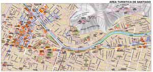
| Tourist
Map of Santiago |
|
Geographic
Location:
Santiago is located 543 meters above the sea level,
in the central part of chile; 2.501 kms south of Arica,
the most northern city of the country and 3141 from
Punta Arenas, the most southern city in Chile 100
kms separate it from the coast of the Pacific Ocean
and 40 kms from the Andes Mountains.
|
|
| |
|
|
|
|
|
 |
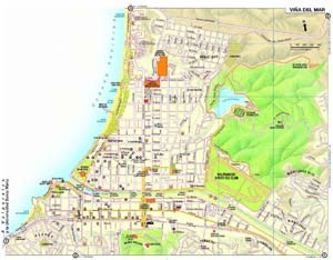
| Map of Viña
del Mar |
|
Geographic
Location:
It´s located 112 km north of Santiago and forms conurbación?
with Valparaiso, in front of the Pacific Ocean and in the
opening of the Marga Marga river. It is also known as the
City of Gardens
|
|
| |
|
|
|
|
|
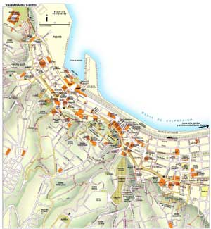
| Map of Valparaiso |
|
Geographic
Location:
It is located 112 km to the northwest of Santiago on an ample
bay of the Pacific Ocean. It has a population of 275,000 inhabitants
approximately. It is an important marineport and industrial
center, as well as one of the greater cities of the country.
Among its economic activities the food processing, the preparation
and the manufacture of fabrics are emphasized as well as petrochemical
products.
|
|
| |
|
|
|
|
|
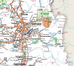
| Access Maps
to Valle Nevado |
|
Geographic
Location:
It is located 4 kilometers from Santiago,
near the way to the Cajon del Mapocho. Its height reaches
between the 2,860 and 3,670 meters. It was inaugurated in
1988 and has a capacity for 800 people (lodging). Cabins
do not exist, but it is complete equipped, which makes it
one of the greater centers of ski of the country.
|
|
| |
|
|
|
|
|
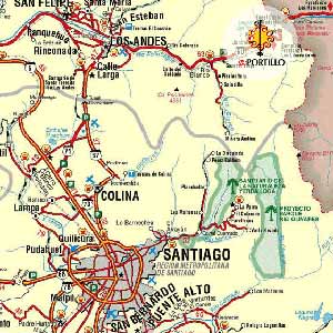
| Access Maps
to Portillo |
|
Geographic
Location:
Portillo is only 2 hours from Santiago by an ample route,
without much traffic and safe. If you travel from Santiago,
follow these simple instructions to arrive at Portillo:
From Santiago, via Américo Vespucio take the independencia
exit "Freeway los Liberators". Continue north via
the by pass Portillo avoiding to enter Cuidad de los Andes,
which joins the International road
|
|
| |
|
|
|
|
 |